On 10 November 2026 Algeria’s official gazette published a decree creating a National Archaeology Agency under the presidency. Signed on 4 November, it gives the agency a role in shaping national research, conservation and public education, from coordinating field projects to designing the elements of a national museum. At Tipasa, on the Mediterranean coast west of Algiers, those duties meet an existing network of researchers, site managers and land use authorities. The decree establishes a body that can coordinate their work; it does not itself change the boundaries of the protected site or say which work will be funded there. [1] [2] [3]
The agency is a public establishment with financial autonomy. Its governing board, chaired by a representative of the presidency, includes representatives of ministries responsible for culture, research, finance, local government and the environment, among others. A director general runs the agency, and a scientific council brings in specialists. Giving those offices a common institution may make it easier to coordinate decisions that previously sat in different administrative files. It still matters which office decides each question. A research project, a development decision and a public explanation of what a site contains draw on different kinds of authority. [1] [2] [3]
The distinction is visible in the provisions on excavation. The 1998 heritage law gives the minister responsible for culture the authority to initiate or authorise archaeological prospecting and excavation, including on private and public land. The 2026 decree assigns the new agency a broad role in developing and coordinating research projects, including new or expanded excavations. It also provides for linking relevant research bodies and museums with the agency, with the arrangements left to a separate text. The decree does not spell out how every existing permit or museum responsibility will pass from one office to another. An agency built to steer a project and an office empowered to issue an authorisation can both shape what happens on the ground. [1] [2]
There is already public expertise to draw on. Algeria’s research directorate describes the National Centre for Research in Archaeology as responsible for work such as mapping archaeological resources and developing atlases for planning and heritage management. The agency decree envisions territory by territory documentation, national risk maps and databases covering discoveries and methods. A national inventory could make it easier to compare records from different research teams. Its usefulness to a provincial office, a teacher or a research student still depends on what the agency collects, how often it updates the records and which parts it makes accessible. The decree sets responsibilities for sharing knowledge; it does not specify a public access regime for every dataset. [1] [8]
The scientific council can propose and adopt research projects and suggest committees to follow them. The supervising authority appoints its members on the director general’s proposal, while members elect their own chair. Together those rules show how scientific judgment enters the agency and where appointments remain in executive hands. They also clarify a distinction that can otherwise disappear in talk of national coordination: the council’s adoption of a research project is one institutional act, while the statutory authorisation to excavate is another. The decree puts both questions into view without documenting how the offices will handle a particular proposal from Tipasa. [1] [2]
The coastal site has long been recorded through choices about what should be measured. In 1894, during French colonial rule, Stéphane Gsell’s study of Tipasa identified excavated monuments and drew them together into an account of an ancient city. Gsell’s work remains a source for monuments that researchers can compare with what is visible now. The authors of a modern survey point out that publications from the early excavations and the more systematic work of 1948 to 1961 do not supply the stratigraphic information needed to reconstruct the city’s development in detail. A record can preserve the location of a building yet tell us relatively little about the layers underneath it or how different uses followed one another. [4] [6]
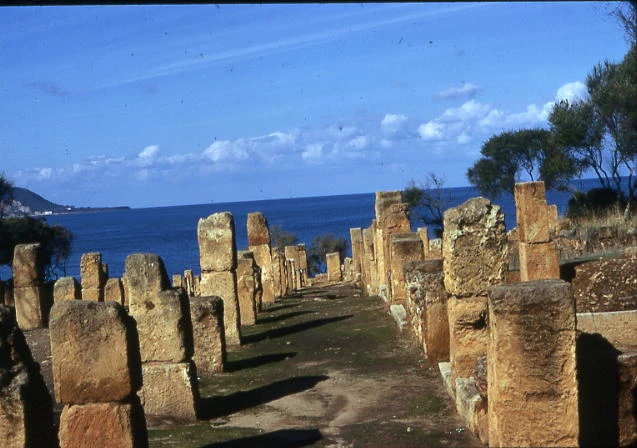
Michel-Georges Bernard’s photograph from 1971, nine years after Algerian independence and eleven before UNESCO inscribed Tipasa, shows stone remains set against the Mediterranean. It records how the visible coastal site appeared from one position at a particular moment. The ground beyond the frame cannot be evaluated from it, and the image alone cannot tell a viewer which features were excavated or why they were displayed. Read alongside Gsell’s account, it shows why a record of exposed monuments is an essential but narrow part of an archive. The history of the place also includes the connections between the ancient town, the surrounding land and routes along the coast. [3] [4] [6] [7]
The 2021 survey published by Alejandro Quevedo, Jesús García-Sánchez, Rafik Khellaf and Youcef Bensaidani took that wider territory as its subject. The team combined imagery, field survey and the study of archaeological material. It reports surveying 197 units and recording 20 sites, while cautioning that coverage remained limited. The researchers explain that vegetation, terrain and surface conditions influence which material can be seen and collected. They also describe how urban growth constrains field access and why older satellite imagery helped them examine changes to the shoreline. An inventory can make these differences visible by distinguishing places that were searched from places where surface evidence was difficult or impossible to read. [4]
The point matters for people who use the land around a protected site. A blank area in an archaeological record may reflect a field team’s limited access or poor visibility, and not the absence of remains. Conversely, the discovery of material does not itself settle how the land should be used. UNESCO identifies urban development and unregulated tourism as pressures on Tipasa and describes existing national and municipal planning instruments. Decisions over those pressures therefore involve the provincial and communal bodies that administer land and services as well as the researchers who can explain what an archaeological record contains. A national agency brings another institution into that process, with a remit to coordinate across sectors. [1] [2] [3] [4]
The chronology also helps separate an international designation from Algerian administration. The World Heritage Committee inscribed Tipasa in 1982 and approved a clarification of the property’s boundaries in 2009. The listing describes management by a cultural property office in coordination with the provincial culture directorate and refers to a land occupation plan approved by the municipal assembly. Those are records of different decisions at different scales. They do not show that every part of the landscape studied by archaeologists has the same formal protection. Indeed, extending an inventory beyond the inscribed property is useful partly because it allows planners to see evidence that the international boundary was not designed to capture. [3] [4]
L. Benali Aoudia and D. Belkacemi Zebda approach the Royal Mausoleum of Mauretania, part of the Tipasa property, through the landscape around it. Their study argues that the setting should inform how the monument is protected and presented. This perspective shifts the practical question from keeping the structure intact to considering how nearby development, access and the surrounding views affect its meaning. It is different from the survey team’s question about the distribution of material evidence, although the two can inform the same planning decision. Research may indicate where to investigate; landscape analysis can identify relationships that a construction decision could permanently alter. Neither paper is an adopted plan for the new agency. [3] [4] [5]
Keeping an inventory and making it useful to the public also involve different choices. A researcher may need precise locations to compare survey records, while a visitor may need a map legible enough to see how the town and coast relate to each other. The decree’s provisions for risk mapping, public communication and common signage give the agency a basis for attending to both. Tipasa’s research demonstrates why public interpretation should explain uneven evidence without necessarily publishing sensitive coordinates. That would give people a way to understand why an unexcavated parcel can merit attention, without treating everything that appears in a survey as ready for display or unrestricted access. [1] [3] [4]
The decree sets out a further public role: contributing to education and developing signage that describes sites and objects in national and foreign languages. It also tasks the agency with developing the elements of a museum that would present archaeology within a national narrative. At Tipasa, the research suggests a concrete way to do that work. An exhibition could distinguish the occupation of the coast from the colonial history of excavation, then show how Algerian and international researchers used different evidence to revisit the area. The national story would be easier to scrutinise if visitors could tell what comes from excavations, what comes from a later survey and what remains a matter of interpretation. [1] [3] [4] [6]
The decree lists possible income, including an initial state allocation, state contributions and receipts from the agency’s activities. It also provides for certified accounts and an annual activity report to be sent to the supervising authority and finance ministry after approval by the board. These are reporting duties and allowable sources of money, not a published allocation to Tipasa. For the people working around the site, the difference will become apparent in what the agency actually supports: for example, whether budgets fund conservation and research beyond the monuments already visible, and whether local institutions can use the information in planning. The annual reporting process creates a place where those choices can be recorded, even though the decree does not say those reports must be made public. [1] [3] [4] [5]
Algeria’s new agency has powers to propose national policy and bring together work that crosses the boundaries of individual sites. Tipasa shows why coordination is valuable, and why it is not the same as control of every decision. An archaeological report may speak to what is buried, a conservation study to what ought to be protected and a planning instrument to what can be built. The agency’s contribution will be clearest when a reader can follow those different records into a named decision: who recommended it, who authorised it, and what Algeria’s public institutions provided to carry it out. [1] [2] [3] [4] [5]
- [1]Algerian Official Gazette. Presidential decree 26-352 creating the National Archaeology Agency4 November 2026; published 10 November 2026
- [2]Algerian Official Gazette. Law 98-04 on the protection of cultural heritage15 June 1998
- [3]UNESCO World Heritage Centre. TipasaUndated listing; accessed 14 November 2026
- [4]African Archaeological Review. The Territory of Ancient Tipasa, Algeria: Archaeological Survey, Material Culture, and Connectivity in Central Maghreb2023; field campaign in 2021
- [5]
- [6]École française de Rome / Persée. Stéphane Gsell, Tipasa, ville de la Maurétanie Césarienne1894
- [7]Michel-Georges Bernard / Wikimedia Commons. Tipaza.ruines romaines.jpgPhotographed in 1971; exact date unknown
- [8]Algerian Directorate-General for Scientific Research and Technological Development. Centre National de Recherche en ArchéologieUndated profile; accessed 14 November 2026
Did this publication help you understand the topic?
0 voluntary responses. Browser-based participation; responses are not a representative survey.
We welcome suggestions, contributions and recommendations.
Editorial standards ↗