Kilwa Kisiwani and Songo Mnara stand on separate islands off southern Tanzania. UNESCO’s record identifies coral-built mosques, houses, public spaces and commercial connections reaching Arabia, India and China. Gold and ivory from the African interior formed part of these exchanges. The surviving urban fabric places African merchants and communities within the production of these connections, with a history extending across many centuries. [1]
In 2016, Stephanie Wynne-Jones, Mark Horton, Jeffrey Fleisher and Jesper Olsen’s team excavated a four-by-four-metre trench south of Kilwa’s Great Mosque. Their 2018 account explains how deposits were recorded separately, sieved and sampled for carbonised plant remains. Successive floors, ash spreads, postholes and building materials preserved changes in occupation. The method connected objects to particular deposits and activities, allowing the chronology of everyday settlement to enter the interpretation of a city known for its monumental architecture. [2]
The researchers also examined the assumptions behind Neville Chittick’s earlier chronology. Named rulers, imported ceramics and traditions recorded in the Kilwa Chronicle had helped organise its phases. The 2016 campaign sought an independently tested sequence through stratigraphy and radiocarbon sampling; dating was still underway in the 2018 chapter. Its proposed revisions belong to that stage of research. Distinguishing the excavation, proposed chronology and subsequent testing preserves how a historical account is constructed and revised. [2]
Wynne-Jones and Fleisher’s 2012 study examines 64 copper coins recovered during the 2009 excavations at Songo Mnara. Thirty-three could be identified. Their findspots included domestic rooms, spaces beside a well and an area around a tomb. Within House 44, coins occurred in deposits associated with cooking and other household activities. These associations gave the objects a social setting: money circulated through spaces in which people prepared food, worked and moved through the town. [3]
The study records clipped and pierced examples and substantial variation in coin weight. The authors use these features to investigate small transactions, commemoration and other forms of value. They treat particular uses as interpretations supported by context. A pierced coin permits an argument about suspension or display; its exact wearer and occasion remain unidentified. These finds come from Songo Mnara. Keeping that location explicit prevents a regional coin type from being confused with an excavation at Kilwa Kisiwani itself. [3]
A 2023 study by Esther Brielle and colleagues, including Chapurukha Kusimba and researchers from eastern African institutions, examined ancient DNA from 80 individuals at six coastal towns and an inland site. It identified ancestry connected to Africa and Asia and inferred mixing beginning around AD 1000. The sampled coastal individuals dated approximately AD 1250–1800. These results add evidence about family formation and mobility within the long history of Indian Ocean connections. [4]
The authors explain that several sampled burial groups were mainly associated with Muslim elites; the social context of others was less certain. Sample composition therefore matters when interpreting the findings. Their archaeological discussion also identifies continuities in local crops, crafts and ceramics, alongside Kiswahili’s Bantu linguistic foundations. Ancestry, language, religious affiliation and urban institutions are distinct historical questions. Studying their relationships requires evidence appropriate to each, with the sample’s dates and social position kept visible. [4]
The British Institute in Eastern Africa’s digitised Kilwa collection preserves photographs, artefact records and field notebooks from Chittick’s excavations in the 1960s and early 1970s. The Archaeology Data Service published the collection in 2021 and updated it in 2024. Its introduction identifies notebooks as a means of following the excavator’s interpretative reasoning. Such records make the production of archaeological knowledge itself available for investigation, including the places selected for excavation and the objects recorded. [5]
The collection also separates several forms of documentation: views of monuments, photographs of finds and records of the excavation process. These categories answer different questions. A monument photograph preserves a visible condition at the time of recording, while a field notebook can explain how a deposit was understood. Their availability enables later researchers to trace the relationship between an observation and its interpretation. The collection introduction establishes this research pathway; specific notebook claims require examination of the relevant record. [5]
The University of Cape Town-based Zamani Project documents Songo Mnara through spatial records, including three-dimensional models, plans and panorama tours. Its account identifies four field campaigns between 2005 and 2009, covering the palace complex, a mosque and residential buildings. These records preserve relationships of scale and position that can be difficult to follow through isolated photographs. They provide another route into studying the built setting of urban activities and the organisation of movement through it. [6]
The project’s panorama method links full-circle views taken from individual positions into a navigable sequence. Its models identify particular buildings and complexes, allowing their surviving form to be examined together. This documentation creates a dated record of visible structures. Excavated deposits and artefacts add evidence of earlier phases and activities. Bringing these records into a shared research design gives architecture, movement and material traces an identifiable place in an account of how the town was inhabited. [6]
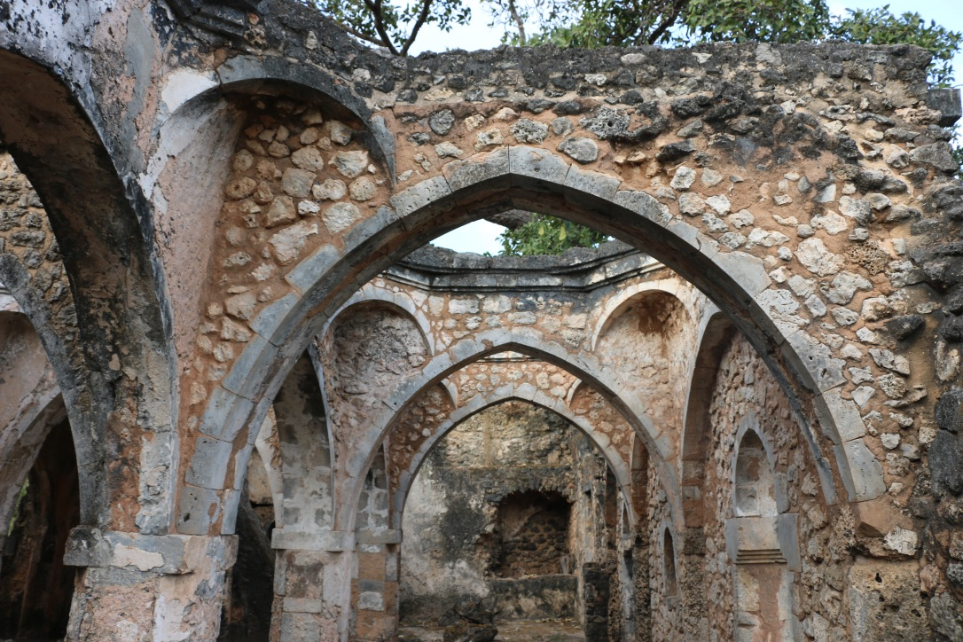
Janetmpurdy’s photograph accompanying this essay shows the surviving interior of Kilwa Kisiwani’s Great Mosque on 16 July 2016. Its arches, masonry and roof openings provide a view of the monument’s material form at that date. The photographer released the image under CC BY-SA 4.0. The image records historical architecture through a modern camera; assigning individual walls to a medieval building phase requires the archaeological documentation discussed above. [7]
Kilwa’s history becomes more detailed when buildings, excavation contexts, objects and records are read together. These sources locate African urban communities within the organisation of commerce and religious life across the Indian Ocean, while preserving the different periods and places represented by the evidence. [1]
- [1]UNESCO World Heritage Centre. Ruins of Kilwa Kisiwani and Ruins of Songo MnaraUndated listing; consulted 15 October 2026
- [2]Stephanie Wynne-Jones, Mark Horton, Jeffrey Fleisher and Jesper Olsen / Aarhus University Press. Dating Kilwa Kisiwani: A thousand years of East African history in an urban stratigraphy, pp. 277–2852018; fieldwork 2016
- [3]Stephanie Wynne-Jones and Jeffrey Fleisher / Cambridge Archaeological Journal. Coins in Context: Local Economy, Value and Practice on the East African Swahili CoastFebruary 2012; Songo Mnara fieldwork 2009
- [4]Esther S. Brielle and colleagues / Nature. Entwined African and Asian genetic roots of medieval peoples of the Swahili coast29 March 2023
- [5]British Institute in Eastern Africa / Archaeology Data Service. British Institute in Eastern Africa Digital Archives: Kilwa Kisiwani—collection introduction2021; updated 2024
- [6]Zamani Project, University of Cape Town. Monuments of Songo Mnara: a Swahili stone townUndated project account; campaigns 2005–2009; consulted 15 October 2026
- [7]Janetmpurdy / Wikimedia Commons. Great Mosque Kilwa Kisiwani Tanzania—original photograph and rights recordPhotographed 16 July 2016; uploaded 1 October 2018
Did this publication help you understand the topic?
0 voluntary responses. Browser-based participation; responses are not a representative survey.
We welcome suggestions, contributions and recommendations.
Editorial standards ↗